The main form of the program sgps.exe
For a list of all members of this type, see SerialGPSForm Members.
System.Object
System.MarshalByRefObject
System.ComponentModel.Component
System.Windows.Forms.Control
System.Windows.Forms.ScrollableControl
System.Windows.Forms.ContainerControl
System.Windows.Forms.Form
serial.SerialGPSForm
Thread Safety
Public static (Shared in Visual Basic) members of this type are safe for multithreaded operations. Instance members are not guaranteed to be thread-safe.
Remarks
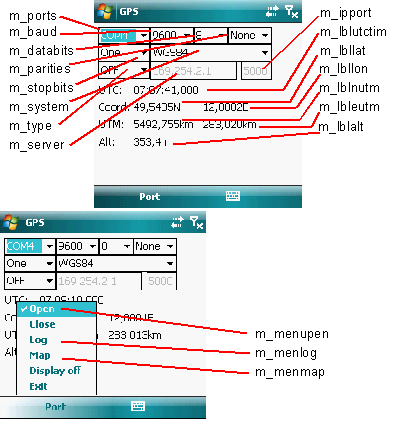
| m_ports | Combo box for selecting the GPS serial port. Contains all serial ports available on the system, see also Serial.COMPORTS. |
| m_baud | Combo box for selecting a baud rate of the GPS serial port. Usually 9600 or 4800 are a good choice. |
| m_databits | Combo box for selecting the number of databits for communicating through the serial port. Usually 8 is good choice. |
| m_parities | Combo box for selecting the parity for the serial port. No parity (None) is the mostly used default. |
| m_stopbits | Combo box for selecting the number of stopbits for the serial port. 1 stop bit (One) could be a reasonable default. |
| m_system | The type of the ellispoid used for convering into UTM coordinates. The mostly used standard is WGS84. See Utils.toUTM() for more details. |
| m_type | The kind in which the application gets NMEA's GGA sequences with GPS coordinates. It may be OFF for getting them from the serial port selected in m_ports or one of TCP, UDP, BCAST for getting them through IP. In this case the IP parameters are defined in the text boxes m_server and m_ipport. NMEA sequences coming on the serial port can be streamed using for example the application s2ip.exe, thus you can use the PDA only as the GPS server and this application sgps.exe can run on a more powerfull desktop computer. See also the documentation of the classes IPClient and IPClientGPS for more details on using IP communication. |
| m_server | The name or IP of the IP server streaming NMEA sequences. Used, if either TCP or UDP has been selected in m_type. No meaning, if broadcast streaming (BCAST) has been selected in m_type. |
| m_ipport | Port on which the TCP or UDP server sends the NMEA sequences, if TCP or UDP selected in m_type. Port on which to listen for NMEA sequences broadcast, if BCAST selected in m_type. |
| m_lblutctim | The UTC time from the last valid NMEA GGA sequence received from GPS. |
| m_lbllat | The latitude in decimal degrees from the last valid NMEA GGA sequence received from GPS. |
| m_lbllon | The longitude in decimal degrees from the last valid NMEA GGA sequence received from GPS. |
| m_lblnutm | The UTM northing coordinate computed from the latitude and longitude for the ellipsoid type selected in m_system. |
| m_lbleutm | The UTM easting coordinate computed from the latitude and longitude for the elliposid type selected in m_system. |
| m_lblalt | The altitude (elevation) in meters from the last valid NMEA GGA sequence retrieved from GPS. |
| Port/Open, m_menuopen | Opens the GPS serial port or the IP communication type depending on the present selection in m_system and starts reading NMEA 0183 GGA sequences. Assuming good outdoor conditions it takes usually several minutes until the first valid GGA sequence arrives and the coordinates are shown in m_lblutctim, m_lbllat, m_lblon, m_lblnutm, m_lbleutm and m_lblalt. The current settings in the combo boxes m_ports, m_baud, m_databits, m_parities, m_stopbits, m_system, m_type, m_server and m_ipport are used for opening, changes in the selections in these combo boxes are ignored until the menu item Port/Open is activated again. Port/Open always closes the presently opened NMEA stream, if needed. |
| Port/Close | Closes the presently opened NMEA stream: serial port or IP client. |
| Port/Log, m_menulog | Switches writing to a gpx file on or off. gpx files may be used in order to store a path for later anylysis using for example Google Earth. This application also writes evtl. exceptions and error messages as comments to the gpx files so that the file may be additionally used for investigating the application errors. The name of the gpx file is estimated automatically by the application, each time the writing to the gpx file is beeing activated. The file name is created as the full path of the executable of this applications completed by the current timestamp and the file extension gpx. See the documentation on the class Gpsx for more details on the gpx format. |
| Port/Map, m_menumap | Activates or deactivates application showing a map for the current position. See the documentation on the class BndBmpForm for more details on how to create maps. The map definitions should be located in the file having the same path as the current executabe with the extension map. For example if the current executable is located in \temp\sgps.exe, then the map definition file should be located in \temp\sgps.map. |
| Port/Display off | Switches the battery-hungry display of the PDA off. No meaning on desktop computers. Running on PDA this application periodically resets the inactivity timer prohibiting the PDA from going into suspend mode and prohibiting the power management from switching the display off. In order to save the battery life time the display may be switched off manually using this menu item. The display may be switched on again by pressing any of the PDA's buttons. See also the documentation of the method Usils.displayOff() for more details on the implementation of this function. |
| Port/Exit | Closes ony operations and exits the application. |
Example
- If you want to use the GPS connected to the serial port of your device, the first obtain a valid serial port. There is no golden rule to find the proper GPS serial port on the PDA. It may be the software device served by the GPS intermediate driver, you may take a look at the registry entries Drivers/Active or just try all of the approx. 10 serial ports available on PDA. Enter the parameters of the serial port to the controls m_ports, m_baud, m_databits, m_parities, m_stopbits. And select OFF in the control m_type.
- If the NMEA stream is coming through IP, for example served by the program s2ip.exe, then select the IP protocol type (TCP, UDP or BCAST) in the control m_type, anter the address of the server in m_server (doesn't matter for BCAST) and the TCP/UDP port of the server or the port on which the client is listening on for the type BCAST in m_ipport.
- Start reading GPS by selecting menu Port/Open. It may take several minutes until the GPS chip finds satelites and the first coordinates in the coordinate labels (m_lblutctim, m_lbllat, m_lblon, m_lblnutm, m_lbleutm, m_lblalt). The GPS chips usually need a good contact to the satelite, they may refuse to work indoor or on bad weather conditions. It his case you will never see any coordinates in the labels.
- With the menu Port/Log creating of GPX files may be switched on or off. Each time switched on, the gpx with the name
sgps<yyyyMMddHHmmss>.gpxis created, where yyyMMddHHmmss is the current timestamp. - Refer to the documentation on BndBmpForm for how to define maps. The map definitions according to BndBmpForm should be prepared in the file
sgps.maplocated in the same directory like the executablesgps.exe. With the menu Port/Map the application showing maps map be switched on or off. A map is shown firs then, when the current coordinate is withing the bounds for the defined maps. On slow PDAs it may take some time, until the map bitmap will be entirelly shown on the screen. Currently the map application doesn't scroll automatically to the point on the map corresponding to the current position, so that you'll have to scroll in there by yourself. For example the following filesgps.map:11d59m05.60sE 49d33m16.05sN 12d00m36.03sE 49d32m21.97sN sbach.bmp 6d37m44.00sE 43d16m26.95sN 6d39m10.66sE 43d15m29.04sN sttropez.jpg
defines two maps, one for Schnaittenbach and one for St. Tropez. Assuming the existence of correct bitmap files sbach.bmp and sttropez.jpg you won't see the maps until you come to one of these charming cities. - Menu Port/Display off switches the battery-hungry display off. The display may be switched on again by pressing any of the PDA's buttons.
- Menu Port/Exit closes the applications. Menu Port/Close closes reading from the GPS port. The application consumes currently a big amount of resources and it may be necessary to close reading GPS in order to do some other resource consuming tasks on the PDA, like watching MPGs or listening MP3s. Sorry, but on the cheaper divices you won't be currently able to use sgps.exe and do other things parallelly.
Requirements
Namespace: serial
Assembly: sgps (in sgps.exe)
See Also
SerialGPSForm Members | serial Namespace | BndBmpForm | Gpsx | IPClient | IPClientGPS | Serial | SerialGPS | Utils.toUTM() | Utils.displayOff()